SUKAMADE BEACH -EAST JAVA - BANYUWANGI

merapi-mount
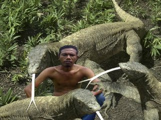
Sukamade beach is one of the attractions listed in the zone of intensive utilization of Meru Betiri National Park with huge potential for ecotourism activities. Attractions that can be done is to observe the turtles laying eggs, the release of hatchlings, bird watching, camping, observation rafflesia, and canoeing.
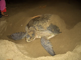
Sulamade coast is the habitat where the turtles lay their eggs. in this place, tourists can witness directly the activities of sea turtles ride to the beach, laying eggs or simply step aside. In this place there are also semi-natural hatchery to incubate eggs - eggs that have been collected by the officers. tourists can actively participate in turtle conservation efforts by following the release of hatchlings into the sea after hatching in the semi-natural.
facility located at this location include: cabin tours, camping ground which is equipped with a pavilion for meeting rooms, shelters, street tourist trail, information center, laboratory and cottage work.
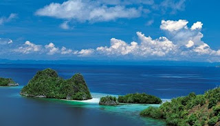
Other attractions in the coastal mangrove forests Sukamade is located on the east coast estuary Sukamade. can be used canoeing rivers in the afternoon while making observations of birds (bird waching) such as RKO - Morocco, eagles, sea virgin, virgin and many more sea birds can be observed. this is done while waiting for the sunset.

Lake Toba - Sumatra

lake tobaLake Toba is one of the largest lake in the world, and the largest and most popular in Indonesia. Lake of the sea as more or less the extent of 100 km x 30 km. In the middle of the lake, there is a large island, Samosir Island is located at an altitude of 1000 meters above sea level.

surfer girlLake Toba is a large lake, 100 km long and 30 km wide, in the middle of the northern part of the Indonesian island of Sumatra, Indonesia. When you see it you will probably be amazed of its natural beauty and lovely landscapes, but do not forget how it was formed in the past. The enormous inland lake has a history spoken of in local myths, but the true story of Toba and how this enormous inland lake evolved, lies in knowing the story of its Toba volcano.

In 1949 the Dutch geologist Rein van Bemmelen reported that Lake Toba was surrounded by a layer of ignimbrite rocks, and that it was a large volcanic caldera. Later researchers found rhyolite ash similar to that in the ignimbrite around Toba (now called Young Toba Tuff to distinguish it from layers deposited in previous explosions) in Malaysia and India, 3000 km away. Oceanographers discovered Toba ash, with its characteristic chemical “fingerprint”, on the floor of the eastern Indian Ocean and the Bay of Bengal.


Lombok Island

island in the sunlombok islandLombok Island
is situated just to the east of Bali, and can be reached in just 25 minute by plane or an hour by the new fast boat service from Bali. Lombok is rapidly emerging as the new Indonesian destination and is a haven for those seeking the unspoilt beauty of the” Bali of old”. Indeed many people refer to Lombok as “ Bali.

Lombok has a great variety of waves that work on all swell and wind conditions. It’s right next to Bali, yet far less crowded. The book tells you where to stay cheaply close to the best fun waves, and where to go when the swell gets up and you’re ready to tackle hollow overhead barrels. Lombok’s Gili Islands offer a peaceful escape for a bit of snorkelling and partying too.

Lombok has been an ideal surfing destination for years. Surfers, especially those that come to Indonesia to surf and are prepared to venture further than Bali, which is being, consumed by its own crowds, will discover Lombok rewarding beyond all expectations.

Lombok surfing is less crowd and its good starting point to search secrete spots on east of Indonesia as its neighbor island is Sumbawa where you will find super suck, Yoyo’s or Lakey pipe in Dompu region.

This island, which measures about 80 kilometers north to south and about 70 kilometers east to west, is a much drier and tougher island than generally verdant Bali. This is perhaps why the Sasak (most of population’s ethnic group) name for Lombok is Bumi Gora, which literally means “The Dry Farmland”. The most awesome physical attraction on Lombok is Indonesia’s tallest volcano, the 3726 meter high Gunung Rinjani.

Komodo Island

islandisland hospital penangKomodo Island In accordance with the name, Komodo Island is an island that is known as a habitat for native animals Komodo dragons (Varanus komodoensis), by local residents, this animal is called Ora. Up to now, Komodo animals become a source of pride because of the local income from the tourists who visit the island that has more than 4,000 lives this.In this island, tourists can see the animal.

Komodo Island is an island located in the Nusa Tenggara Islands. Exactly at Komodo district, West Manggarai regency, East Nusa Tenggara Province, Indonesia. Komodo Island is the western end of East Nusa Tenggara Province, bordering the province of West Nusa Tenggara.

Since 1980, the region is an area of 1817 km2, a National Park by the Government of Indonesia, which are then recognized by UNESCO as a World Heritage Site in 1986. Together with two other large islands, the island of Rinca and Padar, Komodo Island and several small islands around it continued to be maintained as natural habitat of reptiles.

Ijen Crater (kawah ijen)

crater lakecraterIjen Crater (Kawah Ijen)

The volcanic cone of Ijen dominates the landscape at the eastern end of Java. Crater of Ijen is filled by a spectacular turquoise blue lake, its surface streaked in wind-blown patterns of yellow sulphur. Kawah Ijen is the world's largest highly acidic lake and is the site of a labor-intensive sulfur mining operation in which sulfur-laden baskets are.


Ijen Crater is the biggest crater lake in Java. The sulfur crater lake lies between a natural dams of deeply etched rock. It is 200 meters deep and contains about 36million cubic meters of steaming acid water, shrouded in a smelling swirling sulfur cloud. Inside the crater the different color and size of stones are found. Indeed the crater of Ijen is beautiful garden of stone as well.

The view of sulfur miners who climb and go down to the crater is also amazing. A man puts about 10 kg of yellowish stone in to his basket, before he descends the mountain slope to sell his load, carrying the same basket, going in the same direction, digging the same mineral. It is the natural picture that can be seen everyday.

Ijen Plateau lies in the centre of Ijen-Merapi Malang Reserve, which extends over much of the mountainous region directly west of Banyuwangi and borders on the Baluran National Park in the northeast. As at Mt. Bromo, the caldera is best viewed from the air. Fortunately, almost all commercial flights operating between Denpasar - Surabaya, Yogyakarta or Jakarta usually fly, if not directly over, then close by Ijen plateau, where the seemingly luminous blue/green crater lake forms an unmistakable landmark. It is beautiful scenery and located about 32 km to the north west of Banyuwangi.

The principal attraction at Ijen is the large Crater Lake that has much sulfur, which lies hidden between sheer walls of deeply furrowed rock at more than 200 meters. The Ijen crater itself lies at approximately 2,300 meters above sea level. It forms a twin volcano with the now extinct Mount Merapi. The enormous Crater Lake, which is 200 meters deep and covers an area of more than meters, a million square meters, contains about 36 million cubic meters of steaming, acid water.

Ijen crater shows a special type of volcanic feature common to Indonesia, about 1 kilometer in diameter and 175 meters deep. The floor is covered completely by a warm lake, milky blue green in colours held back by a dam built many years ago by the Dutch, in order to keep the hot, mineral laden water from raining the crop lands below.

The crater can be reached from either the east or the west by any kinds of vehicles, but the second part of the trip covers distance 3 km on foot (jungle track). However, the latter is more popular approach, since the climb from the road's end to the edge of the lake is only one and a half hours. And a walk around the lake takes a full day.

The temperature drops at night, near the crater rim it can fall to about 5° Celsius. The road ends at Jampit, where very basic shelter is available. It is also possible to sleep in the old vulcanology station further up the hill, now used by sulfur collectors, but permission must be obtained in advance.

The sulfur is transported entirely on foot. In the past, horses were used but they were found to be less practical on the hazardous terrain. Today, the mine yields nine to twelve tons of sulfur per day.

Men carry individual loads of up to 70 kg, often barefooted, up to the rim of crater and then 17 km down the mountainside to a factory near Banyuwangi. The porters are paid by weight. The most important advice if you are traveling to Ijen is: "If you lose your way, just look out for the sulfur trail". The meaning was clear, since a continuous flow of two ways traffic, carrying the sulfur down the mountainside from the lake and trudging up again to re-load, had left a yellow trail on the well-worn path. The best time for seeing Ijen Crater is at 8 to 9 am.

The Cave Maharani

tourismtravel agentsThe Cave Maharani - Lamongan district
East Java, has a quite famous cave, the cave Maharani. This cave is about 500 meters from the beach north of Java and the depth is 25 meters below the surface. Cave with a 2500 m2 is found on 6 August 1992 by a group of phosphate mining are Sunyoto. Maharani cave and inaugurated by Regent Lamongan on 10 March 1994 as one of the tourism in the District.


Maharani Cave, is located in Tanjung Kodok sea tourism area, Paciran district Lamongan regency, about 200 m from Tanjung Kodok gateway fringe the roadway to east. About 50 m in the south of the street, there is stone that its soil is tire to form the bank that has downwards. Here, some labourers had mine the coral soil, phosphate material and dolomite fertilizer that had sold out of Paciran region. On this area, is a countryside road, which is the footpath, and every day passed by non irrigated dry field farmers, the stone mineworker workers, also once in a while is crowded passed the boy scouts who performing a camp around the area.

This Maharani Cave found by 4 labourers who being led by Mr. Sugeng. This cave had found on 6 Augusts 1992. The name of this cave had selected by the situation of the beautiful cave like a palace from a beautiful queen. Before the invention, one of the members, had dream, she had met with a beautiful woman who had a beautiful as the property of a queen that called Maharani. The queen seems to be a head time door of the cave that had found. The name of this empress has specified by the fact of this cave condition. In platform of the cave named Paseban Maharani, there is stone which has crown form, the property of a queen, which named “Selo Mahkota Maharani”. This beautiful cave room also alike an empire palace of subterranean that is full of graven pillar and roof.

The situation of the nature cave of Maharani Palace is stay at 200 m from Java seashore residing in Tanjung Kodok area, Paciran district, Lamongan regency. This cave is easily to visit and fluent to obtain the transportation towards to the location.

Banjarmasin Float Market

travel agentsBanjarmasin Float Market an Historical Note

Banjarmasin city is one of the big cities in Indonesia, which is located in one of the largest in Indonesia, namely Kalimantan. Banjarmasin into the region in this province of South Kalimantan, as quoted from the Jakarta regional government website, has a broad approximately 72 km per terms, or approximately 0.22 percent of the area of South.


Muara Kuin Floating Market is a traditional market which is above the river at the mouth of the Barito river Kuin, Banjarmasin, South Kalimantan (Borneo) . Merchants and buyers use djoekoeng, boats in a language called Banjar. This market began after the Fajr prayer until after 7 o’clock in the morning. Sunrise reflected light between the transaction vegetables and fruit of the vineyard of the villages along the Barito river tributaries and children.

tourismWith a view to see, tourists as though they were sightseeing. A small boat which usually called jukung bring merchandise with vegetables, fruits, all kinds of fish and other household goods available at the floating market. As the sun began to emerge the market gradually began to retreat, the merchants began to leave the floating market to bring the results with satisfaction.

Floating market a unique atmosphere and the typical jostling between large and small boat buyers and sellers seek each other are always milling to and fro, and always shaky play of the Barito river waves. Floating market has no such organization in the market on the mainland, so it does not record how many traders and merchants based on visitors or distribution of merchandise.

Boating women traders who sell their products themselves or a neighbor called the hamlet, while the second hand purchase from the hamlet called panyambangan for resale. The Special of this market is still common barter transactions between merchants and boating, which is in a language called Banjar bapanduk, something unique and rare.

Muara Kuin Floating Market is a traditional market which is above the river at the mouth of the Barito river Kuin, Banjarmasin, South Kalimantan (Borneo) . Merchants and buyers use djoekoeng, boats in a language called Banjar. This market began after the Fajr prayer until after 7 o’clock in the morning. Sunrise reflected light between the transaction vegetables and fruit of the vineyard of the villages along the Barito river tributaries and children.

With a view to see, tourists as though they were sightseeing. A small boat which usually called jukung bring merchandise with vegetables, fruits, all kinds of fish and other household goods available at the floating market. As the sun began to emerge the market gradually began to retreat, the merchants began to leave the floating market to bring the results with satisfaction.

Floating market a unique atmosphere and the typical jostling between large and small boat buyers and sellers seek each other are always milling to and fro, and always shaky play of the Barito river waves. Floating market has no such organization in the market on the mainland, so it does not record how many traders and merchants based on visitors or distribution of merchandise.

Boating women traders who sell their products themselves or a neighbor called the hamlet, while the second hand purchase from the hamlet called panyambangan for resale. The Special of this market is still common barter transactions between merchants and boating, which is in a language called Banjar bapanduk, something unique and rare.

This tourist attraction is often regarded as a fantastic attraction, like the Venice of the East Banjarmasin World, because they both have the potential of river tourism. But both city and nature different cultural backgrounds. In Banjarmasin many found along the river floating houses called lanting house, which is always shaky play of the waves.

Kuin is a type of settlement areas that are along the river flow (waterfront village) that has several tourist attractions, such as nature tourism, cultural tourism and cultural tourism. Closely with the life of the community life of the river like a floating market, riverside village with its traditional architecture. The traffic of traditional boats with a wide variety of cargo is an interesting attraction for tourists, even expected to be developed as tourist villages so that it can be a shaper image in the promotion of tourism in South Kalimantan. Still in the same area, tourists can also visit the Mosque of Sultan Suriansyah and Mausoleum Complex of Sultan Suriansyah, Kembang island, islands and island Bakut Shocked. In Kuin also there for ornamental carving handicrafts Banjar home.


Karimun Jawa Island

travel alertKarimun Jawa Island
is one of the most important islands in Riau Archipelago, due to its thriving economy and proximity to Singapore. Tanjung Balai Karimun is a medium-sized town, with a large Chinese community and shops selling a large variety of imported items. The town is linked by both sea and air.

ARCHIPELAGO KARIMUNJAWA karimun jawa, One of the districts in Jepara is one - the only district in Central Java which separate the sea to the mainland of Java, a distance of 45 nautical miles from the capital district and 60 miles north of the capital. He is a chain of islands - small islands consisting of 27 islands with an area of 7129 hectares and 107 225 ha of water area. Karimunjawa name allegedly taken from the word Keremun or vague - vague, referring to this group of islands when seen from the mainland of Java seem Keremun - keremun or vague - vague. The name was reputedly given at Sunan Nyamplungan come to Karimun (first person who came to set foot Karimunjawa da mainland). Nyamplungan Sunan is one of the Hijra the son of Sunan Muria to Karimun, whose name is perpetuated from where his tomb is in the village of Mount Nyamplungan karimunjawa. Some locations / attractions to visit is Menjengan Small Island, Big Menjengan, Tanjung Gelam, Legon Lele, Genting, Twins, Parang, Pines and Krakal. maritime tourism such as sailing, surfing, water skiing, swimming, sunbathing on white sand beaches, camping, cultural tours, observation of deer and birds and diving / snorkeling. Package tours to visit the island - the island can contact the travel agency in semarang / Jepara (tours 1-7 days). Cultural attractions in the national tamn ie eggs and th Durian festival in january / march in Jepara. The best visiting season: The month from April to October each year. Access to and from the Dewondaru from Jepara coast by plane or by air charter.

Mount Semeru - Lumajang East Java


Mount Semeru is the highest mountain Merapi in Java, with its peak Mahameru, 3676 meters above sea level. crater at the top of the mountain known by the name jonggring semeru saloko.
semeru have dipterokarp forest hill, forest dipterokarp above, Montane forest, and ericaceous forests or mountain forest.

position of this mountain is located between poor districts and administrative areas Lumajang, with geographical position between 8 degrees 06 'south latitude and 120 degrees 55' east longitude.

in 1913 and 1946 have saloka jonggring crater dome with a height of 3744.8 meters until the end of november 1973. the south edge of the crater dome was broken causing lava flow toward the south side of the covering area and candipuro pronojiwo in Lumajang.

the trip takes about four days to climb a mountain peak semeru home - go. to climb a mountain can be reached via the town semeru poor or Lumajang. of our poor city terminal to ride public transportation to the village of overlap. connected again with a jeep or truck vegetables are widely available in the back of the terminal market overlaps with the cost per person USD. 20 000, - up to post Ranu pani.
before we stopped at gubugklakah to obtain permits, with details, license costs USD. 6000, - to a maximum of 10 people, park admission USD. 2000, - per person, insurance per person USD. 2000, -.

using vegetable truck or jeep journey starts from intercropping to Ranu pani, the last village at the foot semeru. here there are checkpoints, there are also stalls and cottages. for climbers who brought the tent fee of Rp. 20 000, - per tent and when the camera is also take charge Rp. 5000, - per piece. in this post, we are able to find porters (local residents to help indicate the direction of climbing, lifting objects and cook). climbers can also be lodged at the guardhouse. Ranu post pani also that there are two lakes with an area of the lake Ranu pani 1 Ha and Ranu regulo lake with an area of 0.75 hectares. situated at an altitude of 2200 meters above sea level.

after arriving at the monument 'welcome', note continues to the left and head toward the hill, do not follow the broad road toward the garden of the population. other than the usual path in the climbers passed, there is also a commonly used shortcut local hikers, this path is very steep.
initial path sloping down the hillside, which is dominated by grassland vegetation - grassland. there are no signs pointing toward the street, but there are signs of distance on each 100 meters. There are many fallen trees and branches - a branch above his head.

after walking about five miles down the overgrown hillside edelweis, and will arrive at rajeng watu. Here there is a very beautiful steep rock. very beautiful scenery to the valley and hills - the hills, which is overgrown with fir and pine forest. can sometimes see clouds of smoke from the summit semeru. to go Ranu Kumbolo still have to travel a distance of about 4.5 miles and to get to the top of the Mahameru still far from Ranu Kumbolo.

bali mountain Mahameru by people believed to be the father of majestic mountains in bali bali and respected by society. and according to public confidence in the Javanese people who write on ancient books which bersal tantu performances from the 15th century, the island of Java at some time floating in the ocean, the waves pushed around there - here. Java island, the gods decided to set, by way of Mount Meru in India move to the top of the island of Java.

Natuna Archipelago

breakaway toursSenoa Island-near with Natuna Island


tauck tours 2011Natuna ArchipelagoThe Natuna Islands
are a 272-island archipelago of Indonesia, located in the Natuna Sea between east and west Malaysia and Kalimantan. The islands are officially part of the Riau Archipelago Province. Natuna is one of the northernmost island groups of Indonesia. The main islands of Natuna Archipelago are Natuna, South Natuna and Tambelan.

Losari Beach


Losari Beach
is
lime light of Makassar city at Indonesian. In the past, As there were many food tent and stalls standing in a row (1 km in length), the beach had ever been called as a beach with the longest table in the world. Nowadays, those food tents and stalls had been relocated in a place nearby the beach. The government of Makassar city has built a 10 km square of ships ...

Benoa Cape

paris tours 2010Tanjung Benoa or Benoa Cape, which locate near by Nusa Dua island, obvious has violent attraction and fun. in the middle of the calm wave at this coast area, obvious keep one million attractions that challenge.
island two and cape benoa, located in end south balinese island but has different fascination.
Meanwhile, cape benoa known as water tour centre begins from parasailing, banana boat, jet ski, rolling donut, flying fish, snorkeling, scuba memving, glass bottom boat + turtle island and another water sport can be enjoyed here. coast here not wavy and calm so that very safe for family holiday with your children.


ent toursCape Location Benoa

Tanjung Benoa or Cape Benoa reside in end south balinese island and near with Nusa Dua island. this area reachable in 30 minutes from Kuta, 35 minutes from Sanur, 60 minutes from ubud and 20 minutes from Ngurah Rai Airport.

Detail Area Maps:

Kuta / Tuban Beach
Legian / Seminyak Beach
Jimbaran Beach

Sanur Beach
Nusa Dua / Tanjung Benoa Area
Ubud Area
Lovina Beach
Candi Dasa Beach


Get more air game at Tanjung Benoa, there is :


Parasailing that is where will you wear parachute umbrella and pulled by speed boat rotation cape coast benoa. so exactly like parachute jumping. this game time is one rotation 4 minutes on the air. string height yg connect between parachute with speed boat approximately 80 meters.


Jetski that is game uses vehicle at coast likes motorcycle. jetski here can not you ride self, must be accompanied by instructor, remember at coast Cape Benoa find many traditional boats and activity watersport another, so that collision can be avoided. don't worry, the this instructor only will drive from coast edge will aim to middle sea, well until there your are driving, the pillion instructor. this game time 15 minutes. if you want exciting drive it, try to dash against wave yg there. . so you will feel the taste sensation drive this jetski.


Banana Boat use single rubber boat, you will be pulled by speed boat will go coast during 15 minutes. load capacity banana boat this max 4 person plus 1 instructor guider. you can ask to plunge during boat walk, or if not want wet. get nice adventure with Banana Boat game...


Flying Fish, Snorkeling, Scuba Diving, and get more games at there.

Get paid To Promote at any Location
 
GO TO TOP

Copyright © 2010 - 2015 Asia Tours Info