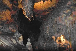
Kiskendo Goa is a natural cave in the mountains notch located 1200 m above sea level. Kiskendo Goa is located about 38 kilometers northwest of Yogyakarta on the northern hill district Kulonprogo, cave Kiskendo jatimulyo located in the village, district girimulya, might be obtained from yogyakarta with less distance, ebih 38 kilometers or less than 21 kilometers from the town of Wates. which can be accessed via a small road was good. only a small four-wheeled vehicles that could be up to this cave. for those of you who came up with big buses must stop at the village Niten, near giri Mulyo district office, about eight kilometers from the cave.not far from the mouth of the cave there was cave Sumitro Kiskendo which has two vertical and horizontal mouth of the river flowing underground clear water. This tourism object is very suitable for camping because of all the caves Kiskendo can enjoy breathtaking mountain scenery. entered the cave Kiskendo, visitors will be greeted by beautiful stalactite and stalagmite like limestone caves in general.
suroloyo peak is the highest hill in the mountainous region located in the hamlet incise keceme, gerbosari, samigalih subdistrict, district Kulonprogo. in addition to having beautiful scenery, this place also has a variety of stories and myths are quite strong.there are two paths to get to this place which is a road Godean - Sentolo - Kalibawang and from street Magelang - Muntilan market - Kalibawang. path to this place is quite difficult because the full ramp and turn - a turn. until now this area is accessible only by private vehicles only.
in areas with an altitude of about 1100 meters above sea level, people can watch such a beautiful landscape. if the weather clears, usually in the morning, one can see four big mountains in Java that is trim, Merbabu, cleft palate, and Sindoro. this place is top of the temple of Borobudur in Magelang also can be seen clearly.
in areas with an altitude of about 1100 meters above sea level, people can watch such a beautiful landscape. if the weather clears, usually in the morning, one can see four big mountains in Java that is trim, Merbabu, cleft palate, and Sindoro. this place is top of the temple of Borobudur in Magelang also can be seen clearly.
Trisik beach is a beach Kulonprogo mining in the district who will be seen if you drove past the track bantul - purwirejo, past and Srandakan balbapang. located in wilayh brosot, Kulonprogo districts, located approximately 37 kilometers from the center of Yogyakarta. terisik beach is located very close to the highway so it is easily accessible with any vehicle.
trip to the beach will terisik teraa fun and not so tiring though quite far. coastal road is very smooth and minimal slope, there are food stalls on either side of the road that could become a place to rest when tired. passing lane and Srandakan balbapang, you will also be able to enjoy views of the river when the bridge connecting Progo Bantul district and Kulonprogo district.
terisik beach is unique compared to the beach - the other beaches in Kulonprogo, namely the coastal village atmosphere that was so pronounced. beach house - home residents, the hut - huts selling food and rural roads located adjacent to each other. diverse activities of local people who utilize coastal ocean as a source of livelihood da also strengthen the coastal village atmosphere.
This beach is located on the west coast of glagahindah, precisely in the village jangakaran Temon district, 15 kilometers from Wates, stretches along 4.5 kilometers. Congot beach location is very easy to reach because it is located only approximately two miles of track across the southern island of Java. Congot beaches are located at the mouth of the river Bogowonto with a beautiful lagoon and there are lots of fish, making it very suitable for fishing activities. a lot of seafood on the beach Congot exploited people around for seafood on the beach Congot use by people around to cultivate fish and shrimps in ponds. terbenan watch the sun above the beautiful lagoon make reluctant to leave the beach Congot.
This beach is located in Kulonprogo regency, Yogyakarta Special Region and is approximately 40 kilometers from Yogyakarta city. This beach is famous for big waves. locations along the coast Glagah to several hundred meters to the west, you can find a lagoon with a water flow toward the river mouth. This coastal lagoon divides into two, the location of which is still covered by some beach plants and grasses and sand dune area that directly borders the ocean. you can cross to the sand dune area through a connecting bridge which is located not far from the river mouth.


