Showing posts with label Tourism. Show all posts

CERME CAVE BANTUL - Central Java

indonesian cave
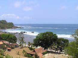
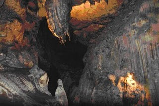
Cerme Cave was originally a meeting place used by Walisongo to disseminate and teach the religion of Islam in Java. The word 'Cerme' comes from 'speech', talks during a meeting held to discuss plans to establish in the Great Mosque of Demak, a northern town in Central Java.
Located in the village of Imogiri Selopamioro 20 kilometers south of Yogyakarta. Goa entire length of approximately 1.5 miles and ends at a river in the region Grill, precisely in the Village Ploso, Girtirto, Gunungkidul District. - Average depth of the water flow of about 1 to 1.5 meters.
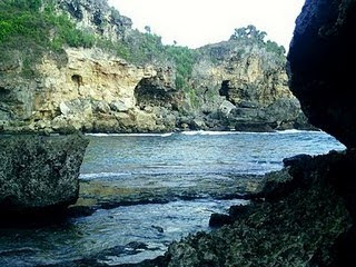
In addition to the main cave there is a smaller cave where the past is used for meditation place like goa puppeteer. Ledhek Goa, goa Badhut, and The Cavern.
on Monday or Tuesday wage many visitors come to ask God's blessings with thanksgiving ceremony. During the holidays, many students and young people to visit this place. Along the hallway there is a stage Cerme cave once used for a meeting place.
To reach the front gate of the cave, one must climb 759 meters of stairs. Better if the visitor to contact the caretaker or watchman cave beforehand to get a proper explanation or information.
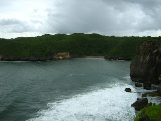
These caves include cave a long and deep. way to achieve this excellent location and distance, about 20 kilometers. The view to the location of the last village is very good. In the daytime, if the weather sunny, yogyakarta city looks beautiful and at night could see the sparkling city lights.
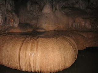
The attraction of the cave Cerme utam This is beautiful stalactite and stalagmite and the existence of many underground rivers and lots of bats hanging in the cave, the conditions in the caves without lighting, darkness and flooded the cave floor, which at penghujann season water will be pairs ( rises), but in the dry season the water subsided. In general, foreign tourists visiting the cave Cerme spend between three to five hours at the location.

Coastal in Gunungkidul - Yogyakarta - Central Java

indonesian coastal
Wediombo coast is natural beach with a beautiful panorama, is located in the Village District Jepitu Girisubo approximately 40 Kilometres south east of the City Wonosari. shaped bays and beaches with white sand, either publicly viewable from the top of the hills and coastline. allowing tourists to enjoy a perfect sunset panorama, besides the fresh coastal air is also believed to help curing asthma. for tourists who like fishing can be done in this place where many fish at a certain moment Panjo that appears along the coast.
Once a year on the beach held cultural tradition that is ceremonial procession NGALANGI catching fish by using a tool made from tree root roses that extends from the hill Kedungdowok fitted and held together - similar to sea by the local community.
in one region to the coast have Gremeng Beach, Coastal and island flying fox Jungwok (island inhabited by thousands of bats) that can be achieved by tracing around 1.5 miles to the east.

indonesian tourismGunungkidul Ngrenehan BEACH - YOGYAKARTA

Located in the village Kanigoro Saptosari District approximately 30 kilometers south of the City Wonosari. tourists can see the activities of fishing activities and enjoy the fish ready to eat or bring fresh fish as a by - by.
Still in the same area with Ngrenehan Beach approximately 1 kilometer to the west coast there are beach ngaboran and Nguyahan. Every full moon day at the beach Ngaboran Nyepi Melasti ceremonies were held.


indonesian beachGunungkidul Baron Beach - Yogyakarta

Baron Beach is located in the Village District Kemedang Tanjungsari approximately 23 kilometers south Wonosari City, is the first beach encountered from shore Regions Combination Baron, Kukup, Throughout, Drini, Krakal and Sundak.
On this beach there is also an underground river that can be used for bathing after playing in the sea. other than that tourists can also enjoy a variety of fresh marine fish fast food, affordable prices, including a menu that is typical of coastal baron snapper soup. on the east side can be achieved through a circular path there are limestone hills, tourists can rest in the substation of view, the beach sipping a refreshing air. Approximately 10 kilometers west from the coast there are beach machete Baron Racuk with the towering steep hill, the courage to challenge the adventure and enjoy the beauty of the sea around freely from the top of the hill.
In each month suro new year local fishermen communities java solemnize marine charity is an expression of gratitude to God Almighty for the abundant harvest of fish and the safety catch fish at sea.

Visitor attractions in Bangkalan City - East Java - Indonesia

Bangkalan District is a district on the island of Madura, East Java Province, Indonesia. The capital is Bangkalan. The county is located on the westernmost tip of the island of Madura, the Border with the Java Sea in the north, east Sampang district, Madura Strait and the south and west.
Kamal Port is the gateway to the island of Java, where there are ferry services that connect Surabaya with Madura (Port, Edge). We have built this bridge Suramadu (Surabaya - Madura), who currently is the longest and largest bridge in Indonesia. Bangkalan is one of the Surabaya area development, and included in the approximately Gerbangkertosusila.
Bangkalan composed of 18 Districts, which are further divided over a number of villages and village. and the Central Government in the District of Bangkalan.


madura beachBangkalan Siring Myrtle Beach - East Java

This beach has a charm and beauty of nature, and this beach was scattered throughout Indonesia. Sand beaches clean and beautiful, making it more unique beach again. Moreover, existing to playing place for children - children who want to spend the holidays with family. Strategic position, making this beach is easy to visit, either by car or motorcycle. More precisely, Siring Myrtle beach this is one beach resort is located next Bangkalan. next to the existing beach tourism in the District Rongkang Kwanyar.


madura island beachBEACH RONGKANG Bangkalan - East Java

Besides Siring Myrtle Beach, the beach is one of rongkang attractions in Bangkalan. An unspoiled place, by trees and rocks beach, make this beach is more unique than the other sights. But unfortunately, this beach has not been managed well by the local government. although its existence is significant to visit.
This beach is located in District Kwanyar and the existing position in the street, makes this beach more accessible by motor vehicle.

Goa Kiskendo - Yogyakarta - Central Java,

goaGoa Kiskendo, Kulonprogo - Yogyakarta

Kiskendo Goa is a natural cave in the mountains notch located 1200 m above sea level. Kiskendo Goa is located about 38 kilometers northwest of Yogyakarta on the northern hill district Kulonprogo, cave Kiskendo jatimulyo located in the village, district girimulya, might be obtained from yogyakarta with less distance, ebih 38 kilometers or less than 21 kilometers from the town of Wates. which can be accessed via a small road was good. only a small four-wheeled vehicles that could be up to this cave. for those of you who came up with big buses must stop at the village Niten, near giri Mulyo district office, about eight kilometers from the cave.not far from the mouth of the cave there was cave Sumitro Kiskendo which has two vertical and horizontal mouth of the river flowing underground clear water. This tourism object is very suitable for camping because of all the caves Kiskendo can enjoy breathtaking mountain scenery. entered the cave Kiskendo, visitors will be greeted by beautiful stalactite and stalagmite like limestone caves in general.

indonesian peakPeak Suroloyo

suroloyo peak is the highest hill in the mountainous region located in the hamlet incise keceme, gerbosari, samigalih subdistrict, district Kulonprogo. in addition to having beautiful scenery, this place also has a variety of stories and myths are quite strong.there are two paths to get to this place which is a road Godean - Sentolo - Kalibawang and from street Magelang - Muntilan market - Kalibawang. path to this place is quite difficult because the full ramp and turn - a turn. until now this area is accessible only by private vehicles only.
in areas with an altitude of about 1100 meters above sea level, people can watch such a beautiful landscape. if the weather clears, usually in the morning, one can see four big mountains in Java that is trim, Merbabu, cleft palate, and Sindoro. this place is top of the temple of Borobudur in Magelang also can be seen clearly.

bali beachTrisik Beach

Trisik beach is a beach Kulonprogo mining in the district who will be seen if you drove past the track bantul - purwirejo, past and Srandakan balbapang. located in wilayh brosot, Kulonprogo districts, located approximately 37 kilometers from the center of Yogyakarta. terisik beach is located very close to the highway so it is easily accessible with any vehicle.
trip to the beach will terisik teraa fun and not so tiring though quite far. coastal road is very smooth and minimal slope, there are food stalls on either side of the road that could become a place to rest when tired. passing lane and Srandakan balbapang, you will also be able to enjoy views of the river when the bridge connecting Progo Bantul district and Kulonprogo district.
terisik beach is unique compared to the beach - the other beaches in Kulonprogo, namely the coastal village atmosphere that was so pronounced. beach house - home residents, the hut - huts selling food and rural roads located adjacent to each other. diverse activities of local people who utilize coastal ocean as a source of livelihood da also strengthen the coastal village atmosphere.

indonesian beachCongot Beach

This beach is located on the west coast of glagahindah, precisely in the village jangakaran Temon district, 15 kilometers from Wates, stretches along 4.5 kilometers. Congot beach location is very easy to reach because it is located only approximately two miles of track across the southern island of Java. Congot beaches are located at the mouth of the river Bogowonto with a beautiful lagoon and there are lots of fish, making it very suitable for fishing activities. a lot of seafood on the beach Congot exploited people around for seafood on the beach Congot use by people around to cultivate fish and shrimps in ponds. terbenan watch the sun above the beautiful lagoon make reluctant to leave the beach Congot.


central java beachGlagah Beach

This beach is located in Kulonprogo regency, Yogyakarta Special Region and is approximately 40 kilometers from Yogyakarta city. This beach is famous for big waves. locations along the coast Glagah to several hundred meters to the west, you can find a lagoon with a water flow toward the river mouth. This coastal lagoon divides into two, the location of which is still covered by some beach plants and grasses and sand dune area that directly borders the ocean. you can cross to the sand dune area through a connecting bridge which is located not far from the river mouth.


Grajagan Beach - East Java - Banyuwangi

international beach
Grajagan Beaches along the south coast of Banyuwangi is promising an unrivaled natural beauty, especially a row of mountains - mountains, plantations, beaches, and ocean expanse stretching from the Indian Ocean. coast between Grajagan, Plengkung and other beaches in TN Alas Purwo.
Grajagan is ideal as a transit point or as a gate to get to the beach Plengkung. besides the location is not too far away to go to TN Purwo Alas, Grajagan also very beautiful and far from the hustle of the city. from Grajagan to go to Plengkung takes about two hours by boat along the shore leases, that trip was almost as if we used the car to pass through the land route. it was due to the macadam road Purwo TN Alas, his condition is very bad.

Grajagan may be an option for tourists who want a vacation in the TN Alas Purwo by boat. an area of 314 hectares of forests are located in the south of Banyuwangi KPH, precisely in the plot or run private curahjati BPKH 111 administrative villages located in Grajagan, purwoharjo district, Banyuwangi.
An interesting journey into the base Grajagan Purwo is to use a boat rental, primarily shoreward ngagelan which is a breeding olive ridley, - gray and green. every night officers here are always looking for turtle eggs for hatching, tourists who've arrived at this ngagelan can directly remove the turtle who is ready and the time is released into the open sea at any time.

Ijen Crater - Banyuwangi - East Java

indonesian crater
Ijen - BANYUWANGI crater situated in Banyuwangi, East Java. This tour has been published and well known to the French state through the impressions ushuwaia Nicolai hulot adventure that shows the explorers.
Ijen crater was easy to be visited through Banyuwangi or Bondowoso, the uniqueness of the main crater of the tour apart from the exquisite a view is to see the traditional sulfur mine is transported by human power endured.
traditional mining was supposedly found only in Indonesia alone (Welirang and Ijen). This remarkable heavy burden for most people, when sulfur is transported through the steep caldera wall and 800 feet down the mountain as far as three kilometers. income received by a taker - average 25 thousand rupiah per day, or about 300 rupiah per kilo.
a bearer is usually only able to bring down one time each day, because the weight of the job. a few hundred yards there is a round building of ancient relics dutch reads 'irrigation crater', is now known as the postal round, a post where the miners weigh the load and get a piece of paper about the content and value.
trips to the crater, starting from paltuding 1600 meters from sea level, a forestry post at the foot of Mount Merapi - Ijen. from here a dirt road climb to an altitude of 2400 meters above sea level with a two hour road travel time to relax. passed along the way a lot of sulfur bearing a friendly exchange greetings. arrived at the crater lip, menabjubkan scene in front of the eye. Tosca green lake with a diameter of 1 kilometer covered in mist and sulfur fumes were far below. miners - these sulfur miners, we need to down the rocky cliffs of the caldera through the impassable trail jaln miners. wet handkerchief is necessary, since often the wind blew the smoke toward the path carrying a decline.
based crater, parallel to the surface of the lake there is a place-making sulfur. thick white smoke came out spraying am iron pipe which is connected to a source of sulfur. 600-degree molten red hot fumaroles calcius tiring out and frozen with cold air, forming a bright yellow solid sulfur.
sometimes uncontrolled burning embers fumaroles, which are usually drenched with water immediately to prevent a chain reaction piroporik. rock - rock sulfur was cut with a crowbar and transported into the basket. miners generally worked, biting piece of fabric or cloth gloves as makeshift air filter.
than directly toward the front of the lake, Tour caldera can be done with more or less takes a whole day. ascent to the crater is generally recommended starting in the morning. for the sake of security welds, climbing down from paltuding Ijen closed after 14:00, because the thick smoke and the possibility of wind direction that leads to a climbing lane. to pursue the journey in the morning, visitors are advised to stay at the nearest location in Bondowoso, montains a clean city, or in Situbondo a coastal town. if you liked the atmosphere of the plantation, a memorable place to stay is the guest house a coffee plantation in kalisat PTP Nusantara XII, jampit. This guest house is located within the plantation housing complex at an altitude of about 1200 meters above sea level. it is also available at the tourist lodge paltuding clean enough, or open the tent at the campground paltuding. temperature - average around the crater is 13 degrees calcius at noon and 2 degrees calcius at night.
to reach the crater today is not too difficult. There are two ways, first through the town of Banyuwangi, as far as 38 miles to the west through the slippery, cashew, paltuding (1600 meters above sea level). The second way is through the city to the east melelui Bondowoso Wonosari, sempol (800 meters above sea level), as far as 70 kilometers paltuding. The second way is the most widely traveled people because of the smooth asphalt roads, while the first way through the rocky road with a fairly steep incline. tourists after a visit in Bondowoso bromo usually comes through, again through Banyuwangi, on to Bali and Lombok.
routes from this Bondowoso through the restricted area of coffee plantations, with three different gates. at every gate we were asked to fill the guest book and travel destinations. sights on this route is very good, with a green garden arabikanya regular coffee, forestry and forest pine forest nature reserve perwan Ijen - trim the foliage. short visit one day can be done, but spent the night in the coffee plantation is the right choice.

Beach Bondo - Jepara Central Java

mount merapi
Jepara is no end to the interesting sights, it's natural if we went to Jepara, then many of the tourists is easy to meet.

In Jepara, is not only known by a variety of tourist attractions such as Sunan Hadlirin religious and historical tourism, say Portuguese Fort and Museum of RA Kartini. In this small town is also known tourist attractions and even the white sand beach.

Jepara is one of the beaches have white sand beach is in Bondo. located in District Bangsri, paving the beach can be used for sunbathing or make a toy with sand media. because the beach is still natural, even the place clean and natural conditions is still a virgin.

one of the visitors, expressing "in addition to the cool weather because adjacent to the rubber and teak forests are also very beautiful beaches and clean".

if the scenery is very nice afternoon with the charm of the setting sun as if - will make the hearts visitors at ease and peaceful.

Plengkung Beach - East Java - Banyuwangi

indonesian beach
Plengkung Beach - Beach BANYUWANGI Plengkung G-Land, 'The Seven Giant Waves Wonder', the nickname was given by foreign surfers to the waves on the beach Plengkung located in Alas Purwo National Park, Banyuwangi, East Java. This beach has three different connotations: Green, because of its location on the edge of the woods, Grajagan, the name of the nearest point before crossing the road in the woods or great because one of the best waves in the world. whatever means, that's the nickname for a local name Plengkung.

waves in the Plengkung is one of the best in the world. 4-6 meter-high waves along the two miles in the formation of seven waves tiered 'go to left' is suitable for left-handed surfers. Plengkung addition to a professional surfer, there is also a stone mace to learn coast. Here the waves are called 'twenty - twenty' which means twenty minute to twenty minute paddle ketengah and enjoy the waves catwalk.
Alas Purwo National Park is also a place other than surfers who can satisfy the passion adventure through the woods, observing wildlife in Sadengan and visited the cave - a mystical cave. Alas Purwo somehow also the most visited for the purpose of the various ethnic and religious backgrounds from all over Indonesia. some people even have survived three years meditating jungle or cave with a potluck meal or leaf meal - obtained by the surrounding foliage. Goa - Goa is a place to meditate Palace Goa, Goa and Goa Princess Padepokan, besides Goa tiger who allegedly had a high mystical value. Goa is in reach of the postal Pancur far as 2 kilometers on foot.

Saweru Waterfall in Madiun

prefecture de tours
saweru waterfall in Madiun - East Java seweru waterfalls situated in the hamlet Seweru, Curry Village, Curry District, Madison County.

location of these waterfalls are still very few people who know, with panoramic unspoiled virgin.
beradadi location behind the mountains and coffee plantation area, making the waterfall is not known by many people.

waterfall was discovered accidentally by one of the local villagers who named Abby Ismani on 25 years ago.

Only after local villagers were pioneered by the young members of Youth, slowly but surely this waterfall is now becoming known by many people. Madison County government even in the near future plan to make this waterfall as the mainstay attractions that highlight the unspoiled virgin.
This tourism object is located nearly 50 kilometers east of the city of Madison. on the slopes of Mount Wilis to a height of 400 meters above sea level, making the path to the location of this waterfall is very interesting.

all the way to this waterfall visitors will be treated to views of nature that is so beautiful, with a steep road conditions, narrow, and slippery makes sense to wonder.
source of this waterfall from the bottom mount and appear in a tree - shade tree.
These attractions frequented by adolescents because of the beautiful and stunning panoramic views, supported by a very cool atmosphere.

there is also agro tourism object that increases the brightness of the environment that is plantation Apples, Citrus Fruits, flower gardens and the Garden of Clove. located not far from the location of waterfalls Seweru.

Long Island - Jepara Central Java

tour

Island is located just 15 minutes from the Beach and Beach Bandengan Kartini. with Sapta boats Enchantment of Kartini Beach or Marine Tourism visitors may satisfied with sea bathing at Long Island.

Long Island itself is only a small island with an area of about 7 hectares, within just filled with trees - wild trees. However, some of this last time, the beauty of this island began disturbed by the hands - the hands of ignorant irresponsible. Corals - beautiful coral with a bandage of clean sea water threatened a distant memory.

When night falls, the fishermen - fishermen from outside the waters of Jepara looting and damaging coral - reef in Long Island. whereas coral - reef is clearly - clearly banned and not allowed to, because it can damage marine life and natural beauty. corals - coral was taken from local fishermen Demak, if there is an approaching fishing boats, the looters are not reluctant - reluctant to threaten.

This island is located precisely at the Kartini Beach Tourism which is only 1.5 miles wide and has about 19 hectares.

prefecture tours
Long Island surrounded by a shallow sea on the basis of coral reefs and white sandy beaches sehigga. Seawater is quite clear and does not have current, making it suitable for bathing, see the coral reefs or just canoeing.

The center of the island is a tropical forest with a tree structure - a large and towering trees interspersed with shrubs and bushes to be a place for sea birds.

Nungnung Waterfall - Badung-Denpasar Bali

city tours
NUNUNG Waterfall is a tourist area which has a fairly extensive parking facilities and access roads to the great waterfall, there's only a little derivative of the stairs - the stairs.

scenery along the way is very green and refreshing. Also very cold air. and no place to rest can we visited.
after walking about 20 minutes, we will arrive at the waterfall which has a fairly heavy discharge of water.
discharge of heavy water and surrounded with bertebangan steam - water vapor that makes the atmosphere became so cool, refreshing and calming.
when we are close to the waterfall we could see the long bridge that connects Bali to Kintamani route, ie Tukad Bangkung Bridge.

Nangnung is the name of a small village, 40 kilometers north of Denpasar with a height of 900 meters above sea level. This tourism object is located in Badung District evening. It lies about - about five miles before the bridge Tukad Bangkung known as the tallest bridge in Asia with a specific height of the pillars reached 71.14 meters.
in this village there is a waterfall with a height of 50 meters with large water discharge. to reach the location of such waterfalls we must trace hilly rice fields about 2 miles from the highway. Nungnung waterfall is one tourist attraction that must be visited when we went to Bali especially for people who love trekking tour, because to get to the location of this waterfall down the stairs that we have quite a lot of numbers, so we can get down to the river valley and can see the waterfall from close range.

ladder - steps to the waterfall is already available and adequate security, even in the valley which is closer to the cave, with leaves and moss-green atmosphere. after the satisfaction of seeing the waterfall the tourists can enjoy special food or simply unwind on the couch - the small bale provided along the path.

This waterfall start promoted as tourist attractions since 1996. since this year, facilities condition Nungnung waterfall has undergone many changes, such as the existence of a range of facilities - other additional facilities to support this tourism object. because it is situated in rural areas, add to the beauty that makes this waterfall interesting to visit. once you visit here will be memorable and make memories that we want to always come to this place again.

SUKAMADE BEACH -EAST JAVA - BANYUWANGI

merapi-mount
Sukamade beach is one of the attractions listed in the zone of intensive utilization of Meru Betiri National Park with huge potential for ecotourism activities. Attractions that can be done is to observe the turtles laying eggs, the release of hatchlings, bird watching, camping, observation rafflesia, and canoeing.
Sulamade coast is the habitat where the turtles lay their eggs. in this place, tourists can witness directly the activities of sea turtles ride to the beach, laying eggs or simply step aside. In this place there are also semi-natural hatchery to incubate eggs - eggs that have been collected by the officers. tourists can actively participate in turtle conservation efforts by following the release of hatchlings into the sea after hatching in the semi-natural.
facility located at this location include: cabin tours, camping ground which is equipped with a pavilion for meeting rooms, shelters, street tourist trail, information center, laboratory and cottage work.
Other attractions in the coastal mangrove forests Sukamade is located on the east coast estuary Sukamade. can be used canoeing rivers in the afternoon while making observations of birds (bird waching) such as RKO - Morocco, eagles, sea virgin, virgin and many more sea birds can be observed. this is done while waiting for the sunset.

Mount Semeru - Lumajang East Java


Mount Semeru is the highest mountain Merapi in Java, with its peak Mahameru, 3676 meters above sea level. crater at the top of the mountain known by the name jonggring semeru saloko.
semeru have dipterokarp forest hill, forest dipterokarp above, Montane forest, and ericaceous forests or mountain forest.

position of this mountain is located between poor districts and administrative areas Lumajang, with geographical position between 8 degrees 06 'south latitude and 120 degrees 55' east longitude.

in 1913 and 1946 have saloka jonggring crater dome with a height of 3744.8 meters until the end of november 1973. the south edge of the crater dome was broken causing lava flow toward the south side of the covering area and candipuro pronojiwo in Lumajang.

the trip takes about four days to climb a mountain peak semeru home - go. to climb a mountain can be reached via the town semeru poor or Lumajang. of our poor city terminal to ride public transportation to the village of overlap. connected again with a jeep or truck vegetables are widely available in the back of the terminal market overlaps with the cost per person USD. 20 000, - up to post Ranu pani.
before we stopped at gubugklakah to obtain permits, with details, license costs USD. 6000, - to a maximum of 10 people, park admission USD. 2000, - per person, insurance per person USD. 2000, -.

using vegetable truck or jeep journey starts from intercropping to Ranu pani, the last village at the foot semeru. here there are checkpoints, there are also stalls and cottages. for climbers who brought the tent fee of Rp. 20 000, - per tent and when the camera is also take charge Rp. 5000, - per piece. in this post, we are able to find porters (local residents to help indicate the direction of climbing, lifting objects and cook). climbers can also be lodged at the guardhouse. Ranu post pani also that there are two lakes with an area of the lake Ranu pani 1 Ha and Ranu regulo lake with an area of 0.75 hectares. situated at an altitude of 2200 meters above sea level.

after arriving at the monument 'welcome', note continues to the left and head toward the hill, do not follow the broad road toward the garden of the population. other than the usual path in the climbers passed, there is also a commonly used shortcut local hikers, this path is very steep.
initial path sloping down the hillside, which is dominated by grassland vegetation - grassland. there are no signs pointing toward the street, but there are signs of distance on each 100 meters. There are many fallen trees and branches - a branch above his head.

after walking about five miles down the overgrown hillside edelweis, and will arrive at rajeng watu. Here there is a very beautiful steep rock. very beautiful scenery to the valley and hills - the hills, which is overgrown with fir and pine forest. can sometimes see clouds of smoke from the summit semeru. to go Ranu Kumbolo still have to travel a distance of about 4.5 miles and to get to the top of the Mahameru still far from Ranu Kumbolo.

bali mountain Mahameru by people believed to be the father of majestic mountains in bali bali and respected by society. and according to public confidence in the Javanese people who write on ancient books which bersal tantu performances from the 15th century, the island of Java at some time floating in the ocean, the waves pushed around there - here. Java island, the gods decided to set, by way of Mount Meru in India move to the top of the island of Java.

Sanur Beach - Bali

best toursSanur beach is a historical place because this beach is a beach where the landing of the royal dutch forces when the Dutch attacked the territory during the colonial era Badung.

among tourism, this place was first introduced by the Belgian painter named AJ Le Mayeur and his wife Ni Polok who had settled in Sanur since the year 1937, the year it becomes painfully clear impact on the state of tourism with the establishment of Sanur Bali Beach hotel or inna The Grand Bali Beach, The first and largest hotel in Bali. This place is a tourist attraction that became one of the main tourist destinations in Bali.

in an effort to increase the attraction of Sanur tourist area, since 2006, often carried out Sanur Village Festival. which is a routine annual event held in Sanur. This event initiated by communities Sanur, Sanur development through foundations and supported by local governments Denpasar.

Sanur Beach is one of the most attractive beaches in Bali. located six kilometers from the city of Denpasar, Kuta and if from a distance of approximately 15 kilometers to the east, this beach has white sand and very gentle stretching along three miles from north to south with a coastline that faces east and therefore the motion sunrise is seen clearly in this beach.

This area is a great alternative for travelers who are bored with the atmosphere of a crowd of Kuta, Legian and Seminyak. In this place where tranquility and comfort are felt far away. but compared to Kuta, the rate of hotel in this area is more expensive than other places in Bali.
very clean beaches and waves crashing in the middle of making this place became one of just a fun place for swimming, canoeing, or just snorkeling.

this place is becoming known as the tourist attraction since its establishment hotel bali bali beach or call now at Inna Grand Bali Beach, this hotel is the largest and the first hotel in Bali. and since then, this place is more known and crowded by foreign tourists and local tourists.
Get paid To Promote at any Location
 
GO TO TOP

Copyright © 2010 - 2015 Asia Tours Info